
Bikepackia
Real routing engine · not AI-drawn lines

Pack a bike.
Gosomewhere
real.Describe the trip. Mec, your route partner, plans the days and stops — and a real routing engine draws every line, so it's actually rideable.

Plan your first trip→Learn more
FREE AI PLANNER FOR YOUR FIRST TRIP · NO CARD
Made by bikepackers, for bikepackers
Get it on Google PlayFREE ANDROID APP · IOS TO FOLLOW
START · GrenobleDay 2 · Villard-de-LansDay 3 · ResupplyDay 4 · Col de RoussetFINISH
Real routing, not AI lines
OSM
Export to any device
GPX
Stages + stops planned
Multi-day
To plan your first trip
€0
STEP 01

Explore your options

Ask in plain language — "suggest a 3-day ride near Paris" — and Mec sketches real route options to choose from, ranked to your taste.

Plain-languageRanked matchesNo blank map
Suggest a 3-day ride near Paris↵
3 ROUTES FOUND · TAP TO OPEN
Vexin Plateau Loop
Gravel · quiet lanes
212 km
↑ 1,840 m
BEST MATCH
Chevreuse Forêt Tour
Mixed · forest
188 km
↑ 2,210 m
Seine Valley Run
Road · river-side
236 km
↑ 1,260 m
STEP 02

Plan the whole multiday trip

Turn the route you like into rideable days — balanced distance and climbing per stage, with water, resupply and viewpoints pinned along the way.

Day stagesBalanced climbingPOIs pinned
ÎLE-DE-FRANCE · 212 km · 3 DAYS
Day 1Paris → Mantes74 km↑ 620 m
Day 2Mantes → Giverny68 km↑ 710 m
Day 3Giverny → Paris70 km↑ 510 m
STEP 03

Line up the boring stuff

A bed near the end of every day, plus water, food and groceries — found and pinned to the day on the map, before you even pack a bag.

Places to stayWaterFood & groceries
A BED EVERY NIGHT · FOUND
NIGHT 1
Le Relais de Mantes
Hotel · 300 m off route
km 72SET AS STAGE END
NIGHT 2
Gîte des Peupliers
B&B · 400 m off route
km 141NEARBY
2 nights pinned · water mappedYOU BOOK DIRECT
STEP 04

Export the GPX and ride.

Export your route as a GPX file and load it on your head unit or phone app. Your device handles the turn-by-turn on the bars — and every water and resupply stop rides along as a waypoint.

GPX exportGarmin · Wahoo · phoneWaypoints included
DAY 2 · ON YOUR HEAD UNITGPX LOADED
1.2 km
Bear right onto Chemin des Crêtes — gravel
41.2
km done
↑ 380
m climbed
16:40
ETA camp
Water stop aheadFontaine de Giverny — pinned on your route
What's in the bagThree things, done very well

Smart routing. A real mec. Logistics that don't suck.

01 · SMART ROUTING

Routes you can actually ride — drawn by a routing engine, not the AI.

The AI never draws the line. A real routing engine does, on OpenStreetMap data — so every route stays on roads and tracks that exist, on the bike profile you ride, with the climbing laid out day by day before you commit.

Elevation-awareGravel-firstFitness-awareDaylight-awareWind-awareAvoid traffic
12
FRANCE · VERCORS LOOP
4 DAYS · 198 KM
198
km
4,200
m ↑
72%
gravel
2
resupply
02 · MEC

Ask Mec anything about the trip.

Mec is your route partner inside the planner — ask about gear, food, route swaps, or how to soften day four. Every answer is grounded in your actual route and stages, not generic web tips.

◐
Mec
online · planning Vercors loop
  1. You: Got 4 days. Grenoble → Vercors loop. Mostly gravel, hate climbs over 8%.
  2. Mec: Sketched a 198 km loop · 4,200 m, on gravel wherever the tracks allow. The steepest pitch is 9%, on day 2. Want me to find a bed near the end of day 2?
  3. You: Yes — and a water stop for day 3 morning.
  4. Mec: Found 3 places near Villard-de-Lans — pick one and it becomes the end of day 2. Two water taps pinned early on day 3.
03 · LOGISTICS

Beds, water, resupply — pinned to the day.

We find beds, water and food along each day and pin them to the route — then link you to the place's own website to book. You ride.

NIGHT 2
Belknap Hot Springs
Stage end · book on their site
✓ PINNED
DAY 3
Resupply · Sisters Bakery
Bakery · km 41 of the day
✓ PINNED
NIGHT 3
McKenzie campground
Stage end · 1.4 km off route
✓ PINNED
DAY 4
Water · Whitewater trailhead
Tap · km 18
SUGGESTED
How we comparevs Komoot · RideWithGPS · Strava · ChatGPT

See how Bikepackia stacks up.

We turn a plain-language brief into a real route, split into rideable days with stops pinned and GPX export. Here's an honest look at where we lead — and where another tool is the better pick.

See the full comparison→
Capability
Bikepackia
Komoot
RideWithGPS
Strava
ChatGPT
Plain-language trip planning
~
Real OpenStreetMap routes
invents
Auto multi-day stages
~manual
~manual
~missing actual route
Resupply & water stops
~
~
~
Accommodation booking
we find it, you book direct
~thirdparty integration
GPX export
Yes~Partial / manualNoComing soonIncluding the rows where each tool beats us.
A real trip, planned by Bikepackia360 km · 4 days · France

Bordeaux to Nantes, planned in 14 minutes.

We started with "Bordeaux to Nantes, four days, mostly gravel." Bikepackia drew the route via the Marais Poitevin, split it into four days, found a gîte near Niort for night two and a chambre d'hôtes for the last night, and pinned water and a market stop in La Rochelle. The beds were ours to book.

14 min
minutes to plan
€0
cost to plan
3
nights with a bed found
GPX
export to your device
See how it works
12
FRANCE · VERCORS LOOP
4 DAYS · 198 KM
198
km
4,200
m ↑
72%
gravel
2
resupply
Android appLive on Google Play

Plan on phone,
mec will accompany you.

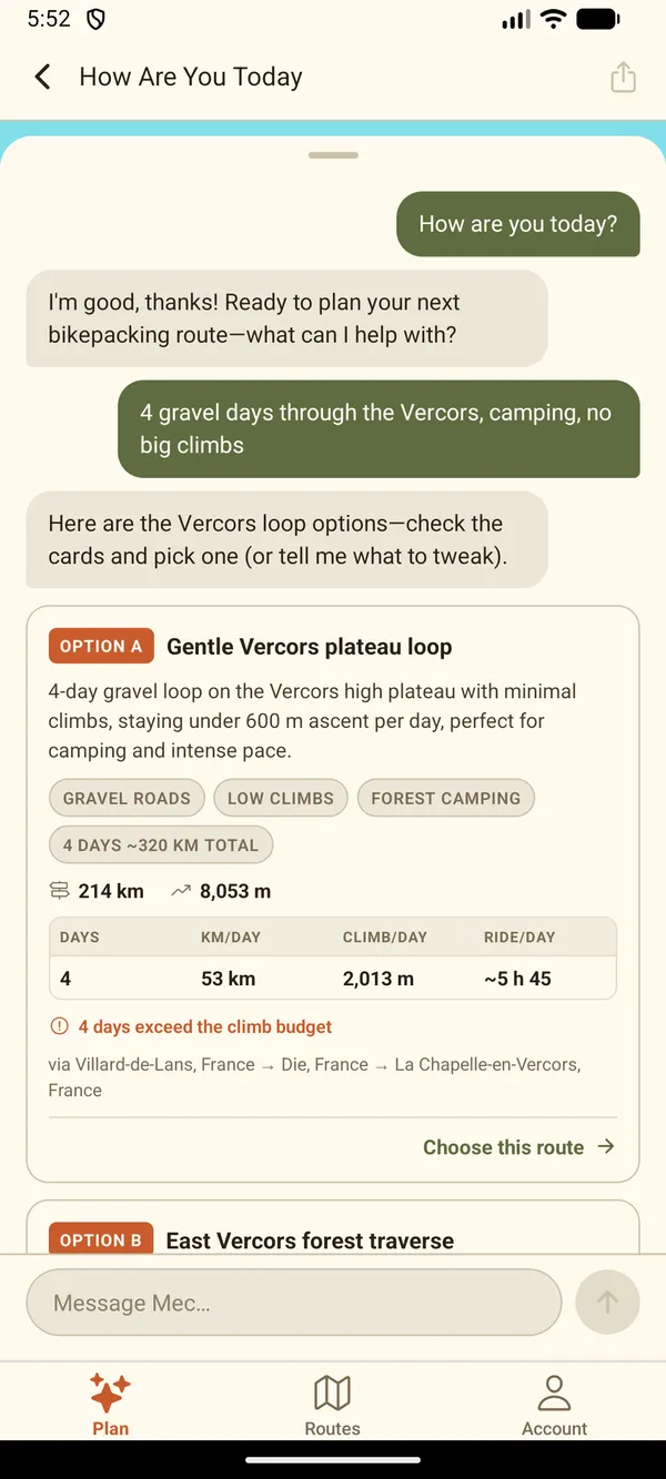
  1. Mec rides along

    Day too long, closed road, sudden change? — tell Mec and the route redraws on the map.

  2. Every day on one page

    Distance, climbing, ride time and destination — review the plan before getting on the bike.

  3. All your trips, one account

    Save a trip on the laptop and it opens on the phone — same routes, same account.

Get it on Google PlayFREE ANDROID APP · IOS TO FOLLOW
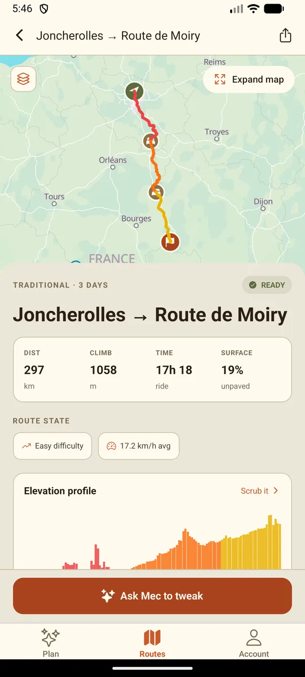
The Bikepackia Android app's route screen: a three-day route across France from Joncherolles to Route de Moiry, drawn on the map in red, orange and yellow day colours with a marker at each stage end, above a READY badge and the trip's numbers — 297 km, 1,058 m of climbing, 17 h 18 of riding and 19% unpaved — and an 'Ask Mec to tweak' button.
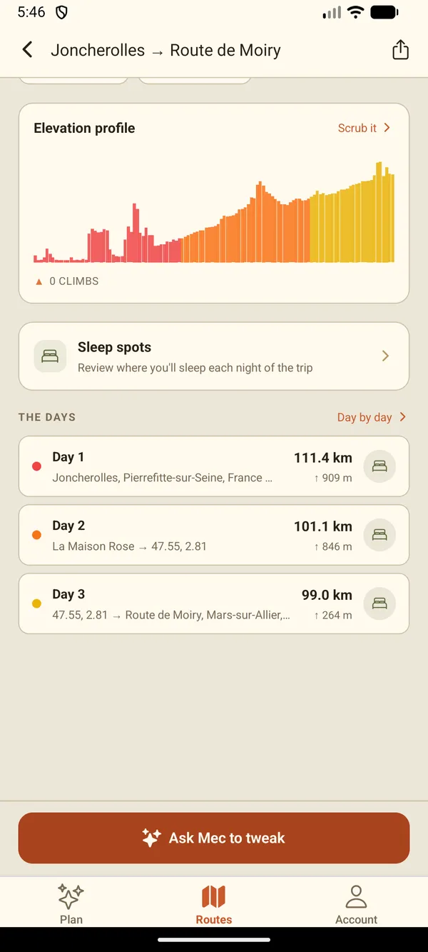
The route screen scrolled to the days: an elevation profile, a Sleep spots card to review where you sleep each night, and three day rows — 111.4 km, 101.1 km and 99.0 km — each with its climbing.
PricingPay only for what you plan.
For our first few lucky users
FREE
€0
no card needed

Try the AI planner with welcome credits. No card required.

  • +€2 welcome credits on sign-up
  • +Mec, your AI route planner
  • +Phased multi-day planning
  • +Stage POIs · picnic, lunch, water, sights
  • +Export GPX to your favorite navigation app
  • +Find places to stay, water and food for every day
  • +Save your preferences for optimal planning
  • +Save routes for future planning
Coming soon
STARTER
€9
per credit pack

€9.00 of AI planning credits. Token-metered; pay only for the prompts you actually use.

  • +Enough for one complete trip planning
  • +Top up to get more routes from Mec
  • +Top up whenever you run low
Coming soon
PRO
€19
per credit pack

€19.00 of AI planning credits. For fine-tuners and perfection seekers — iterate, dial in every detail, and get the route exactly as you want it.

  • +Plan multiple trips in parallel
  • +Iterate on stages and stops until they're right
  • +Refine surfaces, climbs and detours, prompt by prompt
  • +Top up whenever you run low
CUSTOM
Let's talk
bespoke

High-volume planning, custom credit grants, or white-label deployments? We'll size a plan with you.

  • +Bulk credit grants
  • +Dedicated support channel
  • +Usage analytics + invoicing
  • +Volume discounts
FAQ

Things people ask before saddling up.

No. We built this with beginners and veterans both in mind — pick "easy first night out" or "14-day continental divide," Mec scales to you.